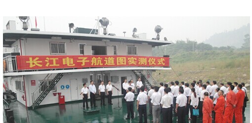
Recently, the Yangtze River Yibin Waterway Bureau held a surveying ceremony of the Yangtze River Electronic Channel Map ( version 3.0). The "electronic channel map" is a marine navigation system similar to the car GPS and mobile APP navigation applications used in automobiles. In recent years, with the rapid development of the Yangtze River water transport, the traditional paper navigation reference map can not fully meet the ship navigation requirements due to the long update period and the timely and effective updating of the navigation channel and navigation mark information. Traditional channel information service methods such as waterway notice, power supply, and information broadcast cannot meet the individualized needs of ship transportation. Building a smart waterway has become the voice of the times.
It is reported that the newly developed Yangtze River electronic channel map timely updates relevant information through digital form, providing accurate navigational parameters such as navigation aids, water depth data, and landforms for ships passing through the Yangtze River, showing ship position, route, heading, speed, etc. Ship status information, designing the best route and ensuring its safe navigation. Through the electronic channel map, users can query the measured water level of each water level station on the Yangtze River and the predicted water level for the next seven days, and estimate the change of the water depth of the channel. Based on this, the changes of the channel conditions are analyzed to rationally plan the navigation line and cargo loading. "With this 'water GPS', we will go where the ship will go, how much can be loaded, and the picture is enough. Unlike the land navigation software, the Yangtze River electronic channel map not only has navigation function. The obvious function is that the typical function of the Yangtze River electronic channel map is the deep-water channel. According to the deep-water channel marking, the dry season and the flood period can use a certain depth of water than the standard scale, greatly improving the cargo load and shipping efficiency."
It is understood that since the Yangtze River electronic channel map system has been put into trial operation on the entire Yangtze River, it has played an increasingly important role in ensuring navigation safety, improving shipping efficiency and improving management efficiency, which has further promoted the development of the Yangtze River Economic Belt.
At present, the upgraded Yangtze River Electronic Channel Map ( version 3.0) system marine terminal equipment has been tested in Sichuan Tianchang Water Transport Co., Ltd. and Sichuan Yibin Wuliangye Anji Logistics Shipping Co., Ltd.
Rubber Conveyor Roller,Pressure Resistance Roller,Corrosion Resistance Roller,High Temperature Resistance Roll
Taixing Jinlong Rubber Rollers Co., Ltd. , https://www.txjinlongrubber.com